A basic workflow for digitizing herbaria
Workflows consist of several steps that, completed in an appropriate order, offer an efficient way for completing a task. With long workflows, there are often alternative paths. This page describes a basic workflow for digitizing a herbarium together with some alternatives that permit adjusting the basic path to accommodate different levels of internet connectivity, equipment, and staffing.
Planning
When planning herbarium digitization, core issues to consider are internet connectivity, available equipment, personnel, and the collection’s condition. If internet connectivity is intermittent or slow, online data entry is not a practical option and georeferencing will be difficult. If there is no imaging equipment, it will be necessary to skip that step. The plan should allow for subprojects of the overall project, perhaps focusing on medicinal species, a family, or food plants. These can make good student projects.
Phase 1. Skeletal data
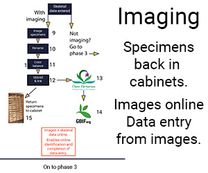
A useful first phase in digitizing a herbarium, particularly if imaging equipment is available, is to record a limited amount of data from each specimen, usually its barcode, taxon name, and the administrative region in which it was collected. This information will enable people interested in particular taxa or particular areas to find the records in your collection and, relatively rapidly, enable you to provide an accurate summary of what is in your collection.

Phase 2. Imaging
If specimen images are available, data entry can be completed from the images, people at other institutions can help you with identifying your specimens and/or correcting errors, and researchers can use them for making measurements (if the image includes a ruler). Useful images can be made with any kind of camera, although the most useful images for research are large, high resolution image. But cell phone images are useful. Consider using them.

Phase 3. Completing data capture
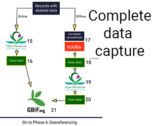
Completing data capture involves entering all the data available on the label that is not part of the skeletal data. When completed, the records become useful for where the taxon has been found, its usual habitat, what it grows with, people’s use of the plant, collectors’ activities, and many other potentially useful bits of information. Some specimens provide very little information, but anyone collecting today should endeavor to provide as much information as possible. Doing so will increase the value of their work.

Phase 4. Georeferencing
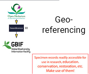
Georeferencing means providing geographic information in a form that can be used to relocate a site and for integrating information about the site with information from other data sources about the site’s topography, geology, temperature regime, biodiversity, human population density, and land use. To make this possible, georeference data includes at least four, and often five, fields. The four fields are latitude, longitude, uncertainty, and the datum used. The fifth field is elevation.

